Road Rides
Easy Rides
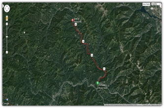
Coeur d'Alene River Rd.
The Coeur d”Alene River Rd ride will take you along and across (several times) the North Fork of the Coeur d'Alene River. The road is paved for 20 miles. There is little traffic weekdays. Summer weekends are very busy.
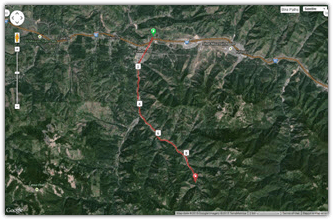
East Fork Pine Creek Ride
The East Fork Pine Creek Ride ride will take you through Pinehurst and then past several abandoned mines. The East Fork road is rough pavement. You will pass several old mine sites.
Kellogg Silverton Loop ("easy-road")
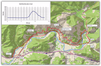
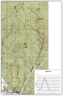
The Kellogg Silverton Loop is potentially four different road bike loops that begin and end at the Kellogg Trailhead on the Trail of the Coeur d'Alenes. If you ride all the way to Silverton, you will have climbed ~400 feet in little over 9 miles. On your return from Silverton, you will pass by a grocery store in Osburn.
- Elizabeth Park Loop: 3 ¼ miles
- Big Creek Loop: 7 ¾ miles
- Gene Day Park Loop: 11 miles
- Silverton Loop: 18 ½ miles
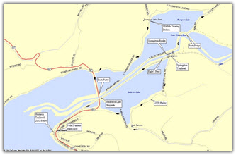
Old River Road Ride
The Old River Road Ride Trail Head is between the Silver Mt parking lot and the Guest House Inn parking lot. The Old River Road is very scenic. The pavement is a little rough. It can be quite busy on summer weekends.
Ride to Murray
The Ride to Murray has some elevation gain, but is not difficult. In Murray, ID. There are numerous old mining buildings The Bedroom Gold Mine and the Spragpole have good food and drink. The Spragpole Museum is very interesting.
Pine Creek Cataldo Loop ("easy-road")
The Pine Creek Cataldo Loop is an easy 12.0 mile ride that starts by going west on Silver Valley Road from the Pine Creek Trailhead through Pinehurst and Kingston to Cataldo. Riders return along the Trail of the Coeur d'Alenes, perhaps stopping at the Enaville Resort for a satisfying meal in an historic building.
Pine Creek Loops ("easy-hybrid")
The Pine Creek Loops compliment the Kellogg Silverton Loop (# 11) in that all routes begin and end at the Kellogg Trailhead, just off I-90 at Exit 51. In the three loops described here, you begin by riding west on theTrail of the Coeur d'Alenes, rather than east.
- CIA Loop: 4¾ miles
- Pine Creek Loop: 10½ miles
- Pine Creek Loop with a climb (~ 250 feet) to Page: 12½ miles
All three loops contain a 2 mile section between the CIA and I-90 that has some pavement, but is mostly packed gravel. All but the last couple of hundred feet can be ridden with tires as skinny as 700C-32.

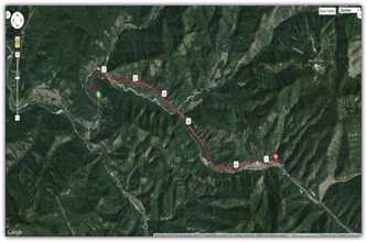
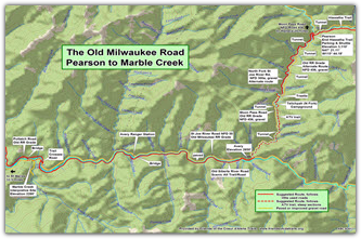
Pearson to Marble Creek ("easy-mountain")
The 23.6 mile Pearson to Marble Creek is ANOTHER ride for those who have already done the Route of the Hiawatha and are looking for something similar, but FREE. This all-downhill ride starts at the Route of the Hiawatha Pearson Trailhead. The trailhead can be reached via the Moon Pass Road (NFD 456) from either Wallace or Avery. This can also be a continuation of a ride down the Route of the Hiawatha. The ride follows the Old Milwaukee Scenic/Alternate Route 10.8 miles, past a newly renovated campground on the North Fork of the Saint Joe River, to Avery (on ATV-wide trail), and then continues another 12.8 miles along the wide Saint Joe River to the Interpretive Center at Marble Creek.
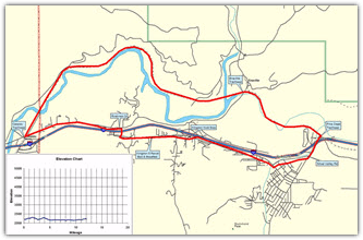
Marble Creek to Saint Maries ("easy-mountain")
The 33.8 mile route from Marble Creek to Saint Maries completes the 300K Bitterroot Loop mentioned on the main Old Milwaukee Road page. This ride starts at the Marble Creek Historical Site that is 35 miles east of St. Maries on the St. Joe River Road. The Historical Site features accessible display shelters, 8 picnic sites, vault toilets, and potable water. Attractions include displays of early 1900s logging, photos, artifacts, and a replica logging flume. This bicycle route and country road, which follows the Old Milwaukee railroad right-of-way, is not paved. The use of mountain bicycles or hybrids is therfore recommended. At one point, a decision about how to get past a barricaded bridge must be made; two choices are presented.
Moderate Rides
Anderson and Thompson Lakes
These beautiful loop trips involve Anderson and Thompson Lakes near Harrison. The mileage in the directions is based on riding around both lakes, a total of 16.2 miles. Each lake could also be circumnavigated as a separate ride. The directions describe how to ride for each option. A bicycle with wide tires is recommended since the roads around both lakes are packed gravel.
Tamerack Ridge Route
The historically interesting Tamerack Ridge Route begins near the oldest building in Idaho, the Cataldo Mission. Canyon Road, Tamarack Ridge Road, and River Road have more hills and less shade than you will encounter along the Trail of the Coeur d'Alenes. If you are starting from Cataldo late in the day, you might want to ride in the opposite direction so that you are on the trail when it is hotter, and on the roads when it is cooler. The 18.7 mile loop could also begin at the Bull Run Trailhead.
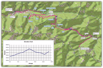
East Portal to Saltese Loop
The 16.2 mile East Portal to Saltese Loop is for those who have already done the Route of the Hiawatha and are looking for something similar, but FREE. This ride starts at the East Portal of the Taft Tunnel and goes in the other direction! You follow the Milwaukee Road railbed east to the town of Saltese, 9 miles away and 700 feet lower in elevation. The return ride is uphill along the Northern Pacific railbed, adjacent to I-90. If you continue west on the Northern Pacific Railroad trail, rather than returning to the East Portal at Taft, you will arrive at Lookout Pass, where you have the choice of two routes down to Mullan and the Trail of the Coeur d'Alenes.
Pearson Avery Figure 8
The 21.5 mile Pearson Avery Figure Eight is ANOTHER ride for those who have already done the Route of the Hiawatha and are looking for something similar, but FREE. This ride starts at the Route of the Hiawatha Pearson Trailhead. The trailhead can be reached via the Moon Pass Road (NFD 456) from either Wallace or Avery. This can also be a continuation of a ride on the Route of the Hiawatha. The ride follows the Old Milwaukee Scenic/Alternate Route to Avery, and returns to the Pearson Trailhead on the Moon Pass Road. The Moon Pass Road from the Pearson Trailhead to Avery is the abandoned railroad right-of-way of the Chicago, Milwaukee and Puget Sound Railway (Note the initials on the tunnel portals). Riders will lose and gain back about 700 feet of elevation as they travel the packed dirt roads.
CCC Road - Wall Road Loop ("moderate-mountain")
The CCC Road - Wall Road Loop is a 13.4 mile mixture of flat and steep terrain that each year, on the Summer Equinox, becomes the venue of a bicycle event that combines the ride with a benefit and BBQ.More information is shown below.
NorPac Trail ("moderate-mountain")
Enhancement and promotion of the NorPac Trail that joins the end of the Trail of the Coeur d'Alenes to the beginning of the Route of the Hiawatha, 22.4 miles away, has been a goal of this organization since its beginning. In 2004, Friends of the Trails was awarded a $21K grant to provide a vault toilet, picnic tables and interpretive signs along this multi-use Northern Pacific railbed. Although the trail follows a paved country road for the first four miles, a mountain bike or other bike with at least 700C-32 tires is needed for the rest of the ride.
Sunshine Mine Ride
The Sunshine Mine Ride will begin on the Trail of the Coeur d’Alenes then continue on Big Creek Road to the Sunshine Mine. Big Creek Road has some rough spots.
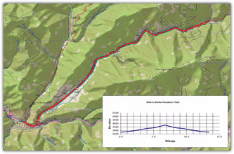
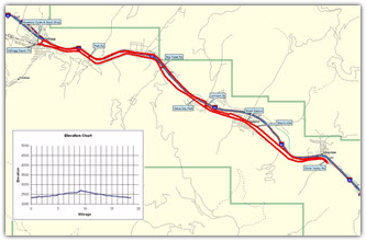
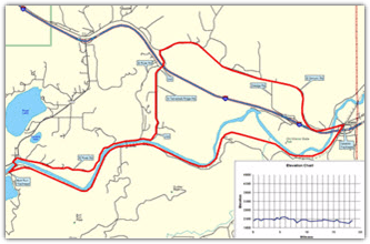
Wallace to Burke ("moderate-road")
The 7.0 mile route from Wallace to Burke takes the rider back in time along a paved country road. This ride will take you through several deserted mining towns on the way to the largest one at Burke. At one time, 5,000 people lived in seven mining towns along this narrow canyon. The road is fairly smooth with long sweeping curves and lightly traveled. There is a 1,000 ft elevation gain in this 7 mile ride. The climb is steady, but not difficult. At one time the Union Pacific and Northern Pacific ran standard gauge rails up this canyon beside a narrow gauge railroad. The boom town of Burke had these rail lines running down main street.
Difficult Rides
Dudley Saddle Loop ("difficult-hybrid")
The expert 15.8 mile Dudley Saddle Loop is for the mountain bike rider who loves to climb. Most of the ride is on dirt or gravel roads. The first five miles consists of a 1450-foot climb. Of course, the next five miles are all down hill to the Trail of the Coeur d'Alenes. The last five miles are on the Trail between Dudley and the Black Rock Trailhead. The only restroom is at the Bull Run Trailhead
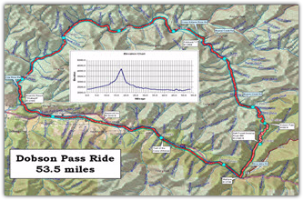
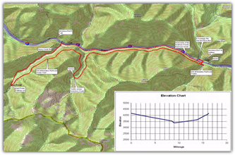
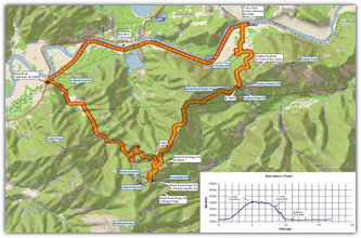
Dobson Pass Loop ("difficult-road")
The expert 52.6 mile Dobson Pass Loop is for the experienced paved road bike rider who loves to climb. The ride starts and ends on the Trail of the Coeur d'Alenes. It leaves the Trail at the Wallace Trailhead and continues on two-lane paved roads over Dobson Pass (elevation 4090 feet) and then returns to the Trail at the Enaville Trailhead. The first 6 miles out of Wallace is a steep climb to the pass. Of course, the next 29 miles are all down hill until you reach the Trail of the Coeur d'Alenes again.
Expert Rides
Coeur d’Alene River Loop Ride
The Coeur d’Alene River Loop Ride will take several days. Check with the trail manager (208)682-3814 before you park overnight at the trailhead.
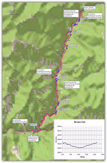
Wallace to Lookout Pass
Here is another way to enjoy the NorPac Trail that involves a bit more adventure... and exercise. This Wallace to Lookout Pass and Back trip starts across from the Wallace Visitor's Center, just off I-90 at Exit 61. You will climb AND descend 2495 feet on this 36.0 mile ride. The first and last 10 miles on the Trail of the Coeur d'Alenes and a country road is easy, and the NorPac Trail up to Lookout Pass is a multi-use dirt road, so the adventure part begins at the Pass when you get on single track trail that descends 4 miles through a cedar and pine forest. The single track is very steep in places.
Beefcamp Jewel Loop ("difficult-mountain")
The Beefcamp Jewel Loop is a rigorous mountain bike adventure through dense forests. It begins just off the Trail in Osburn, and climbs 2240 feet in 10.5 miles, following Beefcamp Trail #102 up to a crows foot junction with Jewel Trail #103, which drops rapidly back to town.